—- En español más abajo—-
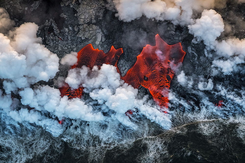
The 2018 eruption was the largest eruption in the lower East Rift (LERZ) of Kilauea in 200 years, producing 24 fissures through which lava flowed at a rate of more than 100 cubic metres per second, filling 0.8 cubic kilometres, the equivalent of 320,000 swimming pools. The collapse of the Pu’u ‘Ō’ō boiler and the Halema’uma’u was accompanied by an earthquake with a magnitude of 6.9. The thickness of the lava reached 280 metres along the coast. Finally an area of 35.5 square km was covered by lava and as a consequence more than 700 structures were affected. No doubt to be able to contemplate the spectacle of creation live, is a privilege, but we must not forget all those who lost their homes due to the eruption.
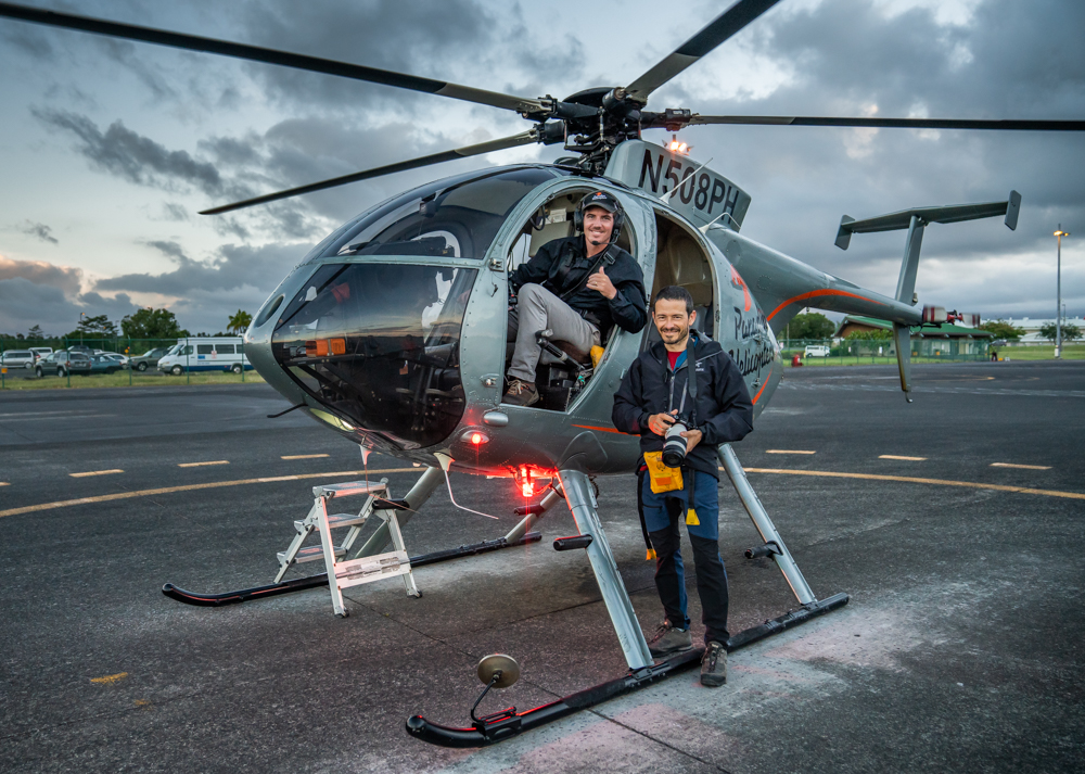
When I embark on a photographic project, I always start with the same question, what do I want to convey with my images? In this case I had no doubt: the violence and the drama of creation. It will probably be generations before there is a new opportunity to see how the landscape is transformed. Changes that usually occur on a geological scale, occur before our eyes in the course of hours. No nature photographer would refuse to let something like that escape! But desire is one thing and reality is another. Because of the enormous restrictions on access to the area and the interest this event caused, I knew I wouldn’t have many opportunities to photograph the eruption. I knew that the best perspective to capture the scale of the eruption would be from the air, so I planned the flights weeks in advance thanks to the support of Bruce Omori, the local reference photographer. I searched for the best available pilot, Daniel Speller, and booked flights late in the afternoon, so that the lateral light would enhance the relief and textures of the clouds and at the same time avoid the excessive contrast between the black lava and the clouds by reflecting direct sunlight.
The entry of the lava into the sea offered the best conditions to achieve my objective. The changing coastline was the border between two worlds: the sea struggling to recover its lost space and the volcano gaining ground meter by meter. And between the two, gigantic clouds of acid vapour rise, fed by the violent waves launched by the Pacific Ocean resisting the knee.
When you’re flying more than a thousand meters in a small helicopter without doors, you must keep your cold blood and concentration to make the most of every expensive minute of flight. We travelled several times along the coastline where the lava entered the ocean. However, the large amount of steam concealed most of the time the rivers and lava lagoons, so it was impossible to photograph them. During a moment the direction of the wind changed slightly, discovering the intense red of the liquid rock. For a moment it seemed to me that the Earth was drawing a face that looked directly at my target, in a scene as disturbing as it was stormy. The image faded in an instant when it was again covered by clouds moving at full speed, but I knew I had got the image!
Only a few days later the eruption ceased almost as abruptly as it began. There is currently no active lava on Hawaii’s Big Island.
This image is the winner of the Earth Enviroments category of the 2019 Wildlife Photographer of the Year.
This is what the jury wrote about the image:»This is a truly inspiring image of a subjet that has been photographed a lot. The combination of the fresh aerial view whit the thoughtful composition, the striking colors the dramatic scene and the association with a red dragon makes the this picture a convincing winner.»
This image has also been recognized as Runner up Landscape European Wildlife Photographer of the Year and 30 Memorial María Luisa Category Winner theme of the year: drone and aerial photography.
If you want to read more about the history behind this image, you can do it in the article dedicated to it in the blog of the Natural History Museum:
https://www.nhm.ac.uk/discover/wildlife-photographer-of-the-year-navigating-the-lava-fields.html
You can see how this image was made in this video
La del 2018 fue la mayor erupción en la parte baja del Rift Oriental (LERZ) del Kilauea en los últimos 200 años, produciendo 24 fisuras por las que manaba lava a un ritmo de más de 100m cúbicos por segundo, llenando 0,8 km cúbicos, el equivalente de 320.000 piscinas. El colapso de la caldera del Pu‘u ‘Ō‘ō y del Halema‘uma‘u fue acompañado por un terremoto de una magnitud de 6,9. El espesor de la lava llegó hasta los 280 metros en la costa. Finalmente una superficie de 35,5 km cuadrados fue cubierta por lava y como consecuencia más de 700 estructuras fueron afectadas. Sin duda poder contemplar el espectáculo de la creación en directo, es todo un privilegio, pero no debemos olvidar a todos aquellos que perdieron sus hogares debido a la erupción.
Cuando me embarco en un proyecto fotográfico, siempre comienzo por la misma pregunta, ¿qué quiero transmitir con mis imágenes? En este caso no tenía ninguna duda: la violencia y el drama de la creación. Probablemente pasen generaciones antes de que se vuelva a producir una nueva oportunidad de ver cómo el paisaje se transforma. Cambios que suelen ocurrir en una escala geológica, se producen ante nuestros ojos en el transcurso de horas. Ningún fotógrafo de naturaleza rechazaría dejar escapar algo así!! Pero una cosa es el deseo y otra muy diferente es la realidad. Debido a las enormes restricciones de acceso a la zona y al interés que causó este acontecimiento, sabía que no tendría muchas oportunidades de fotografiar al erupción. Sabía que la mejor perspectiva para captar la escala de la erupción sería desde el aire, así que planifiqué los vuelos con semanas de antelación gracias al apoyo de Bruce Omori el fotógrafo local de referencia. Busqué al mejor piloto disponible, Daniel Speller, y reservé vuelos a última hora de la tarde, para que la luz lateral potenciase el relieve y las texturas de las nubes y al mismo tiempo evitar el excesivo contraste entre la lava negra y las nubes reflejando la luz directa del Sol.
La entrada de la lava en el mar ofrecía las mejores condiciones para conseguir mi objetivo. La cambiante línea de costa era la frontera entre dos mundos: el mar luchando por recuperar su espacio perdido y el volcán ganando terreno metro a metro. Y entre los dos se elevan gigantescas nubes de vapor ácido, alimentadas por las violentas olas que lanzaba el océano Pacífico resistiéndose a hincar la rodilla.
Cuando estás volando a más de mil metros en un pequeño helicóptero sin puertas, debes mantener la sangre fría y la concentración para aprovechar al máximo cada carísimo minuto de vuelo. Recorrimos varias veces la línea de costa por donde la lava entraba en el océano. Sin embargo, la gran cantidad de vapor ocultaba la mayor parte del tiempo los ríos y las lagunas de lava, por lo que era imposible fotografiarlas. Durante un momento la dirección del viento cambió ligeramente, descubriendo el rojo intenso de la roca líquida. Por un instante me dio la impresión de que la Tierra estaba dibujando un rostro que miraba directamente hacia mi objetivo, en una escena tan inquietante como tempestuosa. La imagen se desvaneció en un instante cuando de nuevo fue cubierta por las nubes que se movían a toda velocidad, pero sabía que había conseguido la imagen!!!
Solo unos días después la erupción cesó casi tan bruscamente como empezó. Actualmente no hay lava activa en la Big Island de Hawaii.
Esta imagen es la ganadora de la categoría Earth Enviroments del Wildlife Photographer of the Year del 2019.
Esto es lo que el jurado escribió sobre la imagen:
«Esta es una imagen verdaderamente inspiradora de un tema que ha sido fotografiado muchas veces. La combinación de la vista aérea fresca con la cuidada composición, los colores llamativos, la escena dramática y la asociación con un dragón rojo hacen de esta imagen una ganadora convincente.»
Esta imagen también ha sido reconocida con la segunda plaza en la categoría de paisaje en el GDT European Wildlife Photographer of the Year y ganadora de la categoría del tema del año, Foto con Dron y Aérea en el Memorial María Luisa.
Si quieres leer algo más sobre la historia detrás de sáta imagen, puedes hacerlo en el articulo dedicado a la misma en el blog del Museo de Historia Natural:
https://www.nhm.ac.uk/discover/wildlife-photographer-of-the-year-navigating-the-lava-fields.html